
Introduction
Most beginner hikers don’t start hiking because they want to learn navigation. They start because they want quiet, views, movement, maybe a little challenge. Navigation usually enters the picture later—often after a moment of uncertainty. A trail that fades. A junction that doesn’t look like the map photo. A sinking feeling that the forest suddenly feels much bigger than it did an hour ago.
This guide is written for the beginner hiker who wants to avoid that moment altogether—or at least be prepared for it. Not by memorizing a checklist of gadgets, but by understanding how navigation tools actually work together on the trail, and why relying on just one of them is rarely enough. New hikers should learn the basics of how to use a compass, understand why navigation is part of the ten essentials, and practice with beginner-friendly orienteering resources before relying on any one tool in the field.
Navigation isn’t about never getting confused. Even experienced hikers second-guess themselves. It’s about having layers of awareness and tools that let you stop, re-orient, and make a calm decision instead of a panicked one. Maps, compasses, GPS units, and phone apps all play a role—but only when you understand their strengths, limitations, and how real-world conditions affect them.
If you’ve ever wondered whether a phone app is “good enough,” why people still carry paper maps, or how a compass actually helps when everything looks the same, you’re in the right place.
This article contains affiliate links. If you purchase through these links, MoreHiking may earn a commission at no additional cost to you. We only recommend gear we trust and have carefully researched.
Core Concept: How Hiking Navigation Really Works
Navigation on trail isn’t a single skill or device. It’s a system made up of information, interpretation, and confirmation. Beginners often assume navigation means knowing where you are at all times. In reality, it’s more about continuously answering three quieter questions: Where am I now? Where am I going next? How will I know if I’m off track?
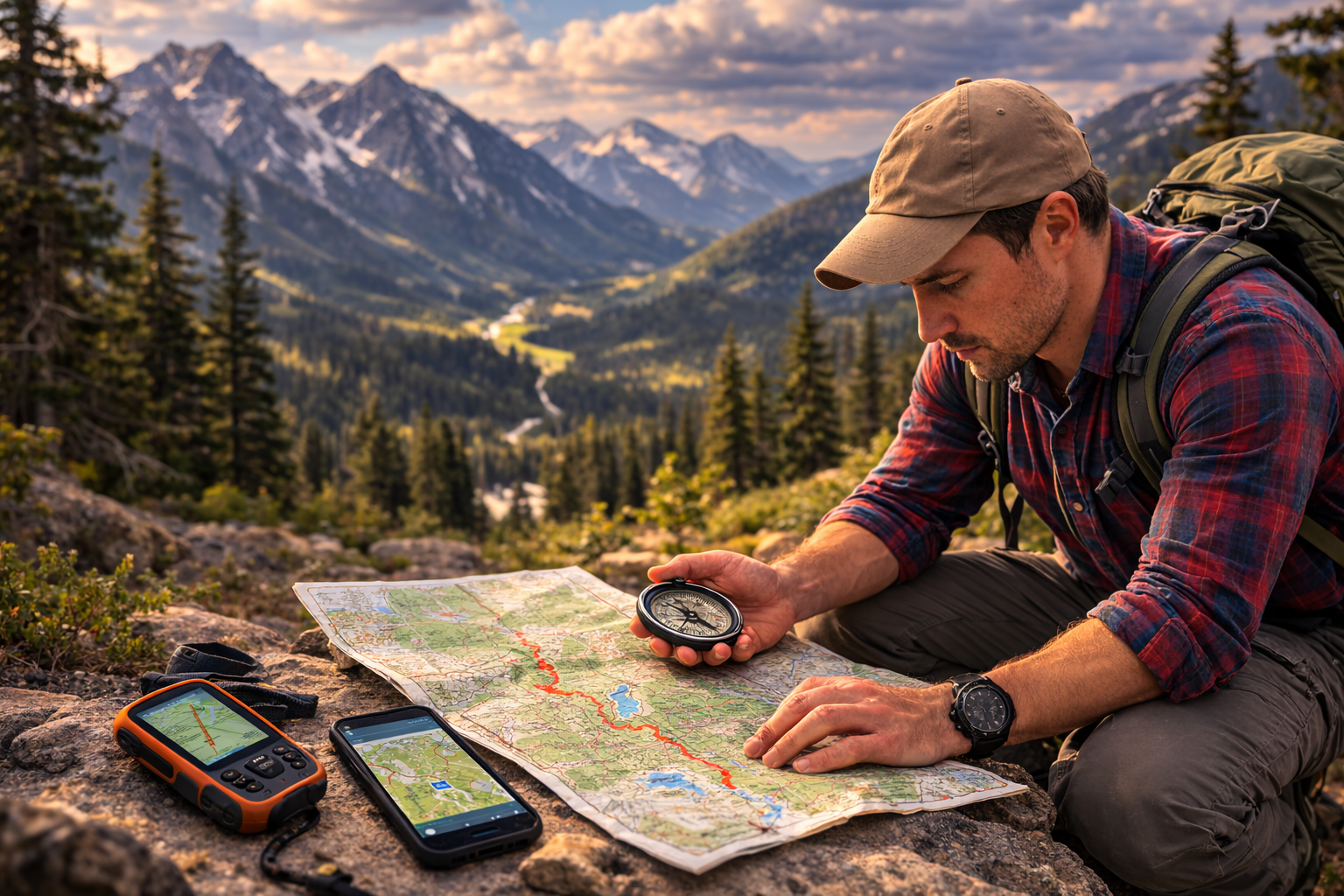
Every navigation tool answers those questions in a different way. A paper map gives you the big picture—the shape of the land, the relationship between trails, water, ridges, and valleys. A compass tells you direction, independent of batteries or signal. GPS devices and apps give you precise location data, often with reassuring certainty. Used together, they reinforce one another. Used alone, each has blind spots.
One of the biggest misconceptions beginners have is assuming trails are fixed, obvious lines on the ground. In reality, trails change. Snow hides them. Leaves cover them. Blowdowns force reroutes. Sometimes the trail is technically there, but visually subtle. Navigation tools help you understand where the trail should be, not just where it appears to be.
Another common misunderstanding is thinking navigation is only needed when you’re “lost.” In practice, good navigation happens continuously. You check your map at trailheads, at junctions, after breaks, and when terrain changes. You confirm direction before committing to a descent. You notice that the creek you expected on your left is now on your right. These small confirmations prevent big mistakes.
For beginners, the goal isn’t mastery. It’s redundancy and confidence. You don’t need to be perfect—you need enough understanding to slow down, assess, and choose deliberately instead of guessing.
Key Considerations & Decision Factors
Redundancy Matters More Than Precision
One of the most important lessons experienced hikers learn—sometimes the hard way—is that no single navigation tool is failproof. Phones die. GPS signals degrade in deep valleys. Compasses get left behind. Maps get wet. Redundancy isn’t paranoia; it’s realism.
For beginners, this doesn’t mean carrying everything imaginable. It means having at least two independent ways to orient yourself, preferably ones that fail for different reasons. A phone app backed up by a paper map and basic compass skills is a strong starting point. If one tool stops working, you’re not starting from zero.
What often trips people up is false confidence. GPS accuracy can make hikers stop thinking critically about terrain. When the screen says you’re on the trail, it’s tempting to trust it even when the ground tells a different story. Redundancy forces you to cross-check. When two tools agree, confidence increases. When they don’t, that’s your cue to stop and reassess.
Terrain Changes How Tools Behave
Navigation tools don’t exist in a vacuum. Forest density, elevation, weather, and even geology affect how well they work. Dense tree cover can reduce GPS accuracy. Steep-sided valleys can cause signal “bounce.” Snow can erase trail tread entirely. Fog can flatten depth perception and hide landmarks you expected to see.
Paper maps and compasses shine in these moments because they don’t rely on external signals. But they also demand more interpretation. A contour-heavy map in rolling terrain can overwhelm a beginner if they’ve never practiced reading elevation lines.
Understanding that tools behave differently depending on where you hike helps you choose appropriately. A well-marked state park loop and a remote alpine trail ask very different things of your navigation system—even if the distance is similar.
Simplicity Beats Feature Overload
Many beginners gravitate toward tools with the most features, assuming more options equal more safety. In practice, complexity can become a liability. A GPS unit with dozens of menus doesn’t help if you don’t remember how to change screens when stressed. A navigation app with layers you’ve never toggled is just noise.
The best navigation tool is the one you understand well enough to use calmly when you’re tired, cold, or second-guessing yourself. That often means starting simple. A clear map. A baseplate compass. A phone app you’ve practiced with before you needed it.
Complexity can come later, once the basics feel intuitive.
Understanding the Main Navigation Tools
Paper Maps: The Foundation of Spatial Understanding
Paper maps are often dismissed as old-fashioned, but they remain the backbone of good navigation. A map doesn’t just tell you where a trail goes—it shows you why it goes that way. Ridges, drainages, elevation changes, and junctions all make sense when you see them in context.
For beginners, the biggest hurdle with maps is scale and orientation. It takes practice to translate a flat image into a three-dimensional landscape. But that practice pays off quickly. Once you understand how contour lines stack into hills and valleys, you start noticing terrain features before you reach them.
Maps also encourage planning. You can see bailout routes, alternate trails, and water sources at a glance. When something unexpected happens—a blocked trail, worsening weather—you already understand your options instead of scrambling to find them.
Maps don’t beep, vibrate, or reassure you. That’s a feature, not a flaw. They slow you down and encourage deliberate thinking.
The National Park Service includes navigation among the essentials of trip preparation and recommends knowing how to use a topographic map, compass, or GPS before heading out.
Compasses: Direction Without Dependence
A compass does one job, and it does it reliably: it tells you direction. That simplicity is powerful. When everything else fails, north is still north.
For beginners, a compass is most useful when paired with a map. It helps you orient the map to the landscape so what you see on paper matches what you see around you. This alone can eliminate a lot of confusion. You stop guessing which way the trail bends because the map is literally aligned with the terrain.
Many hikers carry a compass but never really use it, assuming it’s only for emergencies. In reality, frequent casual use builds familiarity. Checking bearing, confirming trail direction, and orienting maps become second nature over time.
The compass doesn’t replace other tools—it anchors them. At MoreHiking we have developed a post providing a overview of the 5 Best Hiking Compasses for Beginners.
GPS Devices: Purpose-Built Reliability
Dedicated GPS units sit somewhere between traditional tools and modern convenience. They’re designed for outdoor use, with physical buttons, long battery life, and better performance in cold or wet conditions than phones.
For beginners, GPS units offer reassurance. Seeing your location on a track can reduce anxiety, especially on less obvious trails. But they still require understanding. A GPS shows where you are, not whether you should be there. Without map awareness, it’s easy to follow a line into terrain you didn’t intend to enter.
They work best when used as confirmation rather than instruction—checking progress, verifying junctions, or confirming that your interpretation of the map is correct. At MoreHiking we have developed a post providing an overview of the 5 Best Hiking GPS Devices.
Navigation Apps: Powerful, Familiar, and Fragile
Phone-based navigation apps are often the first tool beginners use, and for good reason. They’re accessible, visual, and familiar. Many offer downloadable maps, offline GPS tracking, and user-generated trail data that can be extremely helpful.
The danger lies in overreliance. Phones are multi-purpose devices, and navigation competes with photos, messages, cold temperatures, and battery drain. Touchscreens become unreliable in rain or with gloves. Apps can crash or behave unpredictably after updates.
Used thoughtfully, apps are excellent companions. Used blindly, they create a single point of failure. The key is treating them as one part of a larger system, not the system itself.
How to Think About Choosing Your Setup
Rather than asking “What’s the best navigation tool?” a better question is “What combination of tools makes sense for the way I hike right now?”
For most beginner hikers, a strong starting setup includes:
- A paper map of the area
- A simple baseplate compass
- A phone app with offline maps already downloaded
Beginners who want to build confidence beyond screens can also practice with beginner-friendly orienteering exercises before relying on a single device in the field.
This combination balances understanding, reliability, and convenience. It also scales well. As experience grows, you may rely more heavily on certain tools, or add a GPS unit for longer or more remote trips. But the foundation stays the same.
What matters most is not brand choice or feature lists, but familiarity. Practice at home. Check tools on short hikes. Deliberately navigate even when the trail is obvious. Confidence comes from repetition, not equipment.
Practical Use & Real-World Application
Navigation errors rarely happen all at once. They creep in gradually, often when fatigue, weather, or distraction enter the picture. A missed junction after a long climb. A wrong turn during a conversation. A trail that looks right enough to follow—until it isn’t.
Experienced hikers learn to recognize early warning signs. The map no longer matches expectations. Landmarks don’t appear when they should. Elevation gain feels wrong. These moments are cues to stop, not push forward.
When you pause, use your tools deliberately. Orient the map. Check your direction of travel. Confirm your last known point. Often, the solution is simple once you slow down. Beginners sometimes fear stopping because it feels like failure. In reality, stopping early is success.
Environmental factors amplify mistakes. Cold drains batteries faster. Rain reduces visibility. Snow erases tread. Darkness narrows perception. This is why navigation isn’t just a daytime fair-weather skill. Practicing in mild conditions builds habits that hold under stress.
The most valuable navigation skill isn’t technical—it’s restraint. The willingness to pause, think, and backtrack before uncertainty turns into trouble.
Final Thoughts
Navigation isn’t about fear of getting lost—it’s about confidence in moving through unfamiliar places thoughtfully. The tools themselves matter less than how you use them and how well you understand their role.
Beginner hikers don’t need perfection or encyclopedic knowledge. They need a system that encourages awareness, slows decision-making, and provides backup when assumptions fail. Maps, compasses, GPS units, and apps each contribute something valuable when used together.
The goal isn’t to eliminate uncertainty. It’s to meet it calmly, equipped with understanding rather than guesswork. With time, navigation stops feeling like a safety net and starts feeling like part of the experience—a way of reading the land instead of just passing through it.
Navigation FAQs
Do I really need a map if I have a GPS app?
Yes, though not always in the way people expect. A map gives you context that a GPS screen often can’t. It shows what’s around you, not just where you are. When plans change—or something goes wrong—that context becomes critical. The map doesn’t replace your app, and your app doesn’t replace the map. Together, they reduce uncertainty.
Is a compass hard to learn?
Not at the beginner level. You don’t need advanced bearings or triangulation to benefit from a compass. Simply learning how to orient a map and understand general direction adds enormous clarity. Like most skills, it feels unfamiliar at first and then quickly becomes intuitive with light practice.
Are navigation apps accurate enough for safety?
They can be, but accuracy isn’t the same as reliability. Apps depend on battery life, software stability, and signal conditions. They’re excellent tools when prepared and backed up, but risky as a sole navigation method. The safest approach is to assume your phone could fail and plan accordingly.
How do I practice navigation without getting lost?
Practice when you don’t need it. Navigate on familiar trails. Predict junctions before you reach them. Identify landmarks ahead of time and confirm them as you hike. This builds skill without stress and makes real-world navigation feel routine rather than urgent.
If you have enjoyed this post, perhaps you would like one of our other Posts.


Leave a Reply